Natural capital accounting is the idea that we can quantify the economic value of the benefits we derive from natural resources. These resources include geology, soils, air and water, as well as plants and animals and their habitats. Some natural capital resources are assets that provide us with "ecosystem services" such as food, breathable air and drinkable water, and recreation.
Over the past several years there has been a significant increase in work to develop methods for understanding natural capital. Concerns about air pollution, biodiversity loss, and the effects of climate change have encouraged policy-makers to take a more sustainable approach to development and look for ways of pricing the value of the environment into economic models.
Much of this work involves analysis of geospatial and environmental data. However natural capital accounting requires a wide range of inputs and many key datasets are not readily available.
In its most recent annual report the Natural Capital Commission said "the absence of data on the state of natural capital is worrying" and proposed that there be a five yearly environment census:
… a local natural capital baseline assessment methodology should be developed. This guidance should clearly set out how to undertake a baseline natural capital assessment for specific geographies such as a major river catchment, a city or town, a national park, a coastal stretch or a marine area. The maps and data sets that would enable a baseline natural capital assessment to be carried out for England should be specified and collated centrally by government. This guidance sets should be made freely and widely available. It is recognised that there may currently be intellectual or commercial property issues associated with this but ways of overcoming these need to be found as a matter of urgency. |
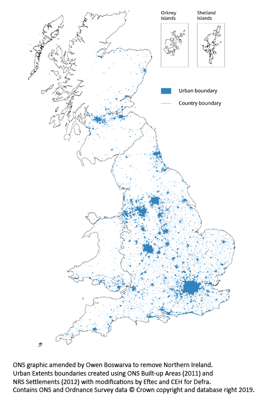
In August the Office for National Statistics (ONS) published a bulletin on UK natural capital with information about green space in urban areas, along with blog post by Dr Adam Dutton, Head of Natural Capital at ONS. The bulletin includes a table of natural capital metrics for thousands of urban areas in Great Britain.
The metrics, calculated by Ordnance Survey, provide estimated areas in hectares for publicly accessible and non-publicly accessible green space, residential gardens, blue space areas, parks and public gardens, golf courses, playing fields, allotments and growing spaces, cemeteries, religious grounds, bowling greens, and other sports facilities. The table also includes counts for some of those features, the number of residential addresses in each urban area, and area estimates for various types of natural land cover.
However the spatial dataset containing the Urban Extents (UE) polygons used to produce the metrics was not released with the ONS bulletin. I submitted a Freedom of Information and re-use request to ONS for the polygons, and they recently released the dataset under the Open Government Licence.
I've combined the Urban Extents polygons for England, Scotland and Wales with the table of metrics and released that version via my Datadaptive site, also under the Open Government Licence.
This is what the polygon dataset looks like:
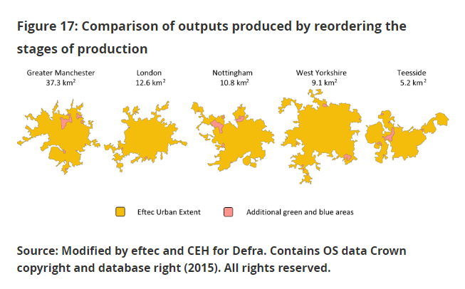
The UE polygons are not an official geography. They were created by eftec for Defra to "address the lack of official geographies that include all green and blue spaces found in urban contexts". However ONS has declined to adopt the polygons as an official ONS-supported statistical geography:
Despite eftec's UE being based on official 2011 ONS built-up areas (BUAs), 2012 National Records of Scotland (NRS) Scotland Settlements and 2015 Northern Ireland Statistics and Research Agency (NISRA) Northern Ireland Settlement Development Limits, the subsequent modifications and their nature, make it unsuitable for an official release. While not incorrect and internally consistent, the methodology and the outputs were based on subjective decisions that the ONS had no influence over. For example, it was found that a simple reordering of the production stages led to a greater inclusion of green and blue spaces in several cases (Figure 17). The Urban Extent product is unlike official products supported by the ONS, such as the 2011 BUAs, which are based on well-documented procedures and had direct involvement from the ONS. More research would be needed to develop this product further and make it an official statistical geography. |
Basically eftec produced the Urban Extents polygons by creating a variable buffer around the extents of existing official boundaries for Built-up Areas (BAUs), and similar geographies for Scotland and NI, and filling in gaps – mostly rivers and inland waters so that blue space was included within the extents.
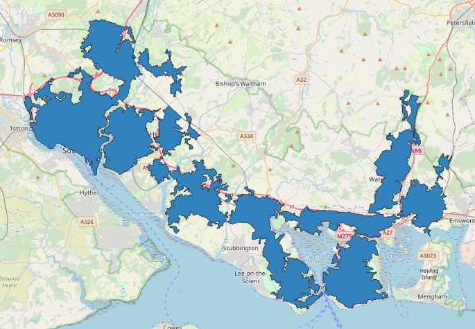
For some urban areas these modifications make quite a different to the size of the urban area. For example this is what the South Hampshire BAU polygon looks like:
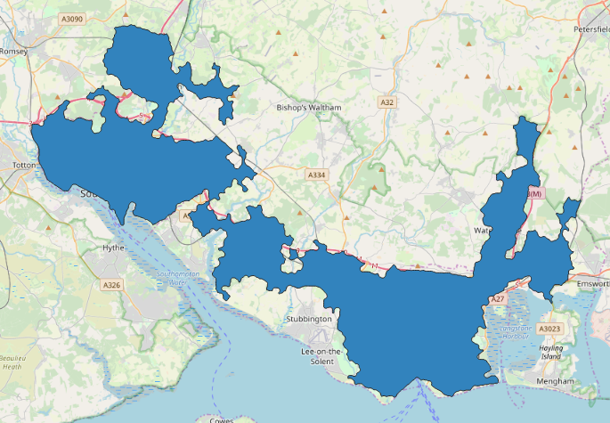
and this is what the South Hampshire Urban Extents polygon looks like:
Clearly there is a need for an official urban geography that can be used for standard calculation and comparison of natural capital assets and effects. However this iteration of the Urban Extents polygons is not that.
I hope ONS and Defra between them can develop something better. This is a tricky problem as it's difficult to see how any of the existing geographies can be adapted for general purposes of natural capital accounting. For some applications it's obviously necessary to have extents that include blue space, because access to rivers and open water has tangible benefits for local people. On the other hand extents that include large areas of water will skew the calculations if, for example, we want to estimate the proportion of an urban area that is given over to golf courses. It's also difficult to provide meaningful metrics for large urban areas such as London or Manchester if the geography treats them as single units.
The need for an official geography would be reduced if more granular input data for natural capital calculations was widely available, because more analysts could build up their calculations from smaller areas. However publicly owned geospatial datasets that are essential for natural capital accounting, such as the OS MasterMap, AddressBase, CEH's Land Cover Map, and the National Soil Map, are sadly not available as open data.
Public bodies such as ONS have access to these data assets through the Public Sector Mapping Agreement and other sharing arrangements. However natural capital accounting will need to move beyond the development of methods. Natural capital is a subject area where there are many interdependencies between datasets. On the one hand there is an opportunity here to achieve multiplier effects by making data more accessible at scale, and on the other hand there is the risk of accumulated friction if data is not readily accessible and re-usable. If natural capital accounting is to be operationalised effectively across the economy, we will need both better collection of environmental data and more geospatial infrastructure datasets published as open data.