Last week the High Court released its judgment in the case of 77m Ltd v Ordnance Survey Ltd [2019] EWHC 3007 (Ch), a commercial dispute about the licensing and re-use of intellectual property.
The judgment is long but very clearly written, and some of the analysis has potential wider implications for re-use of public geospatial data including open data.
77m is a small UK company that has created a dataset called Matrix that would, if brought to market, compete directly with Ordnance Survey's AddressBase.
AddressBase is a data product that contains all of the addresses in Great Britain, matched with their point coordinates. The judgment describes Matrix in similar terms.
In creating Matrix, 77m reportedly accessed at least 18 datasets from various different sources. Some of these datasets contained Ordnance Survey data. The key question in the case was whether 77m created Matrix without infringing any of OS's intellectual property rights.
In his conclusion Mr Justice Birss declares Ordnance Survey the overall winner in the case. However within that outcome there are a series of findings, some of which went in 77m's favour.
The data source most central to the case is the INSPIRE Index Polygons published by HM Land Registry.
The INSPIRE polygons are a dataset of boundaries of registered freehold properties in England and Wales. Land Registry first made this dataset available for public download in 2013, to comply with minimum requirements in the European Union's INSPIRE Regulations.
The INSPIRE polygons are derived from Land Registry's more authoritive Index Polygons, which are in turn derived to a significant extent from data supplied by Ordnance Survey from the MasterMap Topography Layer ("Topo").
Land Registry originally proposed to release the INSPIRE polygons under the Open Government Licence. However Ordnance Survey maintained that the INSPIRE polygons could be used as a substitute for the Topography Layer, and persuaded Land Registry to modify the licensing terms to prevent sharing and most commercial re-use of the polygons.
Under the original download terms for the INSPIRE polygons, users were required to obtain further terms from OS if they wanted to
- use the polygons (including the associated geometry, namely x,y co-ordinates) for a purpose other than personal, non-commercial use or commercial or non-commercial use within your organisation; or
- sub-license, distribute, sell or make available the polygons (including the associated geometry, namely x,y co-ordinates) to third parties.
Land Registry's INSPIRE dataset does not contain any addresses or information on ownership of properties. However each polygon has a unique reference called an INSPIRE ID:
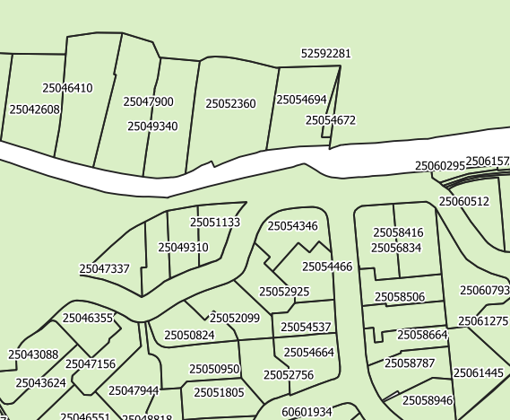
Individual INSPIRE IDs can be entered into a Find A Property (FAP) form on Land Registry's website, which will display an address or description of the land parcel.
With the objective of creating the Matrix address dataset, 77m downloaded the INSPIRE polygons as soon as they became available in 2013 and did a number of different things with the data.
77m calculated centroids from the polygons, and apparently succeeded in matching millions of those centroids to addresses via the descriptions available from Land Registry's FAP service. Some of those descriptions were obtained by employing contract staff in Pakistan to enter the INSPIRE IDs manually. The court found that this practice was consistent with Land Registry's terms of service.
Many more descriptions were obtained by scraping results from the FAP service using an automated process – the court found that this was contrary to Land Registry's terms of service.
Other descriptions were supplied in batches by Land Registry under a separate paid contract with 77m. However the court found that 77m had not been candid with Land Registry about what it was doing with the data.
After some conferring with Ordnance Survey, Land Registry stopped providing further batches of address descriptions for INSPIRE IDs. The court found that this put Land Registry in breach of contract, but rejected 77m's claim that Ordnance Survey had procured that breach.
There are numerous other issues and findings in the judgment related to other datasets used by 77m to create Matrix. The full implications of the case for 77m and Matrix are not yet clear. There will be a further hearing to determine damages and remedies, if any, between the parties.
However there are some particular sections in the judgment that have wider implications for re-use of the INSPIRE polygons and other Ordnance Survey data.
What does this case tell us about the legal status of "derived data"?
Derived data is, broadly speaking, additional data produced by calculation or transformation from existing data. See this 2015 blog post by Leigh Dodds for a more detailed exploration of the concept.
The original download terms for the INSPIRE polygons clearly prevent sharing of the polygons themselves. However one of the issues for the court was whether 77m could provide Matrix customers with centroids and other data elements derived from the polygons:
172. 77m's case is that it does not and does not intend to provide INSPIRE polygons to customers of Matrix. However it does wish to provide the five items of data associated with an INSPIRE polygon. The question is whether these are within the scope of the associated geometry. If they are then 77m is not licensed to provide that data to customers. 173. The operative words are "the polygons (including the associated geometry, namely x,y co-ordinates)". 77m pointed out that when polygons are provided, the manner in which is done is by providing a series of x,y co-ordinates which specify the vertices of the polygon and therefore define the polygon itself. I believe that is what a reasonable objective person knowing the relevant factual matrix would understand the clause to be referring to. Mr Jagot's view seems to have been that this covers any geographic data derived from the polygons. I do not accept that. It is far too wide. An intermediate position was the submission that geometric information like a polygon centroid (which is after all an x,y co-ordinate) and can be said in a general sense to be geometric information associated with the polygon, fell within the clause. I do not agree with that either, for two reasons. First the words themselves are apt to refer to the existing x,y co-ordinates which are already associated with the polygons when those polygons are provided. There is no hint of a reference to derived data. Second, at its heart what is being protected is the polygons. Derived data, whether it happens to be a centroid with an x,y co-ordinate or other geometric information such as the area of the polygon, does not allow the recipient to recreate the polygon. It does not give it away. |
The court found that the download terms did not prevent distribution and sale of data derived from the polygons. However this is only because the court has interpreted "associated geometry" as referring to the polygon alone. Unfortunately the judgment does not explore the status of derived data more generally.
The most we can infer is that intellectual property rights in derived data do not automatically attach to the owner of the dataset from which that data is derived, in the absence of a licence term that specifically covers derived data. Arguably this case establishes a precedent for centroids derived from polygons. However I don't think we can generalise this precedent too far, as other types of derived data may be more likely than centroids to erode the commercial value of the original data.
Does this mean the rest of us can produce and share derived data from the INSPIRE polygons, like 77m?
I don't see why not – but only if you downloaded the INSPIRE polygons before January 2017, when Ordnance Survey applied additional terms to re-use of the polygons. These terms do not permit use of the polygons "for the purpose of creating or developing any product or service intended for sub-licensing, distribution or sale to third parties".
Note that OS might disagree. The last paragraph in the additional terms indicates that OS wants them to apply retroactively. However I doubt that is enforceable because in the 77m judgment the court has clearly decided that Land Registry had the authority to license the polygons on the original download terms.
It is also possible that outputs from Ordnance Survey's 'Open MasterMap Programme' will include a full open data release of the INSPIRE polygons. Open MasterMap was announced in November 2017 and has so far produced no new open data. However a June 2018 post by Land Registry indicated they were thinking along those lines.
Ordnance Survey data in third-party open datasets
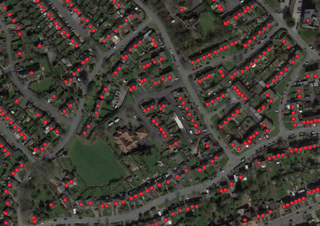
One of the most intriguing parts of the judgment is the discussion of 77m's use of data from Lichfield District Council, in the context of authority to offer a licence.
77m downloaded a number of open datasets "posted by" Lichfield in April 2016. There were about 52,000 records that contained both addresses and geocodes.
The judgment doesn't give precise details but I understand these were datasets that Lichfield published through Data.gov.uk under the Open Government Licence. I think most of the records are likely to have been from Lichfield's Council Tax Bandings by Property dataset, which was removed from Data.gov.uk some time in 2018:
The judgment says:
255. Among the points taken by 77m relating to Lichfield DC, there is one which resonated with me more strongly than the others. I agree with 77m that the Lichfield DC circumstances can be analysed in terms of apparent/ostensible authority from the point of view of a member of the public (77m). OS cited East Asia Company Ltd v PT Satria Tirtatama Energindo (Bermuda) [2019] UKPC 30 as authority for the principle that: "ostensible authority is a relationship between a principal and a third party created by a representation made by the principal, which the third party can and does reasonably rely upon, that the agent of the principal has the necessary authority to enter into a contract on its behalf". 256. This means that to be effective a representation must be by the principal and not the agent. But the Lichfield DC data was made available to the public on a gov.uk website under the OGL terms. On the face of it this was part of a government wide open data initiative. I hold that this does amount to a representation on behalf of the government as a whole, including the Crown and a wholly owned company like OS, that the data was being lawfully made available on those terms. This representation was not just on behalf of the agent (Lichfield DC), it was by the principal. Moreover it would be reasonable for a third party (77m) to rely on it. There is no ostensible reason not to. As regards OS itself, the fact that GeoPlace is not wholly owned by the government is irrelevant since OS is the entity entitled to grant licences in respect of AddressBase. 257. A further OS specific reason why reliance would be reasonable was because before 77m downloaded the Lichfield data in 2016, in February of the previous year OS had a publicly promulgated scheme called presumption to publish which was itself part of the wider government open data initiatives. Under that scheme a public body such as a local authority could publish certain kinds of data to be made available under the OGL. The public authority was simply required to give prior notice to OS. In fact in this case Lichfield DC did not do so but publication of the existence of such notice was not part of the scheme so there would no reason for a member of the public to think it had not been given. The details of the scheme were subject to various details and exceptions. They do not matter. In my judgment 77m is right that from the point of view of the public, it would have been likely that the Lichfield DC data which was made available would fall within the scheme. They would have every reason to assume it was within the scheme and no reason not to. Although he did not accept the conclusion, the answers given in cross-examination of O'Meara of OS on this issue supported 77m's case. His major qualification was that it depended on the data. I agree but the Lichfield data was the kind of data which the presumption to published was concerned with. 258. Therefore I find that from 77m's point of view, the terms of the OGL apply to the data downloaded from Lichfield DC. The OGL permitted 77m to do what it did with that data. |
This is quite radical and has significant implications for public authorities that use Ordnance Survey data under the Public Sector Mapping Agreement.
Basically the court decided that although the Lichfield datasets contained Ordnance Survey data that had not been approved for release as open data under OS's Presumption to Publish process (and indeed would probably not have been approved for release), users who downloaded the datasets were entitled to rely on a reasonable assumption that Lichfield had authority to license OS's IP for re-use as well as its own.
This principle will not necessarily extend to examples where the data contains third-party IP from outside government. However where all of the IP is owned by UK public bodies it reduces the risk for re-users by placing the onus on those public bodies to sort out any errors of authority among themselves.
Where is the public interest in this outcome?
The 77m case is a commercial dispute and has been decided on its legal merits. But the policy context is absurd.
Production and maintenance of AddressBase is sustained for the most part by funding from government, because a national address dataset is necessary infrastructure for the delivery of public services.
Most public authorities have free use of the data. However there are many further applications for high-quality address data that AddressBase cannot support due to Ordnance Survey's commercial terms and restrictive licensing.
Yet we can see from the details of the 77m case that it is virtually impossible to produce an alternative product to fill those gaps in the market. Ordnance Survey, with the support of Treasury and the Geospatial Commission, is operating on a business model that combines the worst features of state monopoly and rentier capitalism.
The public interest would be better served if Government pooled the resources of Land Registry and Ordnance Survey and released the core geospatial data assets of both organisations for wider re-use as open data.
Attribution statement for image of INSPIRE polygons: This information is subject to Crown copyright and is reproduced with the permission of HM Land Registry. © Crown copyright and database rights 2019 Ordnance Survey 100026316.
Attribution statement for image of Lichfield dataset: © copyright and database rights 2016 Lichfield District Council. Contains Ordnance Survey data © Crown copyright and database right 2016. Base imagery © Google.