Update 26 June 2020: HM Land Registry and Registers of Scotland have confirmed that the INSPIRE Index Polygons will be published under the Open Government Licence from 1 July 2020.
Last week I wrote about Ordnance Survey's plan to give other public sector organisations "new freedoms" to publish their own property extents data under the Open Government Licence even if the extents are derived from features in the OS MasterMap Topography Layer.
The following post contains further thoughts on what that might mean for licensing of HM Land Registry's INSPIRE Index Polygons, a dataset of boundaries for freehold properties in England and Wales.
The INSPIRE Index Polygons have been available to download free of charge since 2013. However there are restrictions on how the polygons can be used, because they contain MasterMap data.
Land Registry's conditions of use say:
The INSPIRE Index Polygons and attributes provided in this service are available for use and reuse under the Open Government Licence (OGL). This licence enables public bodies to make their data available free of charge for reuse."
but also:
Under the OGL, HM Land Registry permits you to use the data for commercial or non-commercial purposes. However, as the licence says, OGL does not cover the use of third party rights which we are not authorised to license. HM Land Registry uses Ordnance Survey data in the preparation of the polygons and you will need to comply with Ordnance Survey licensing terms for use of the polygons (including the associated geometry, namely x,y co-ordinates).
Read the Ordnance Survey licensing terms.
The inference is that Land Registry would love to release the INSPIRE Index Polygons as open data (in line with the "open approach to data" in its business strategy) – but those meanies at Ordnance Survey are standing in the way.
Land Registry reportly confirmed this to the Open Data User Group in 2013, before the free downloads were put online:
ODUG understands that HMLR is not providing commercial terms for the bulk purchase of the Index Polygons Dataset as they wish to provide the data as part of their Open Data programme, in line with their overall data strategy, but that this action is currently being blocked by the Ordnance Survey.
Last month there was a shift in Ordnance Survey's position. OS announced that under the new Public Sector Geospatial Agreement (PSGA) it would give public sector organisations "new freedoms" to share data, including publication of property extents:
One of these new freedoms is that from the 1 July 2020 PSGA members will be able to publish property extents created from OS MasterMap Topography Layer under Open Government Licence (OGL) terms, e.g. HM Land Registry and Registers of Scotland's INSPIRE polygon datasets.
OS has set out criteria for publishing OS-derived data in property extents, and specifically highlights Land Registry's INSPIRE Index Polygons as an example of property extents that could soon be published under the OGL.
So all good? We can expect Land Registry to release the polygons as proper open data in July?
Perhaps. But if Ordnance Survey has cleared the way for Land Registry to release the INSPIRE Index Polygons under OGL, why hasn't Land Registry confirmed that publicly? Why wasn't it mentioned in the Geospatial Commission press release along with the other new open datasets planned for July?
OS has been giving its commercial partners a somewhat different message.
In a webinar this week, Ordnance Survey's pricing and licensing lead told partners:
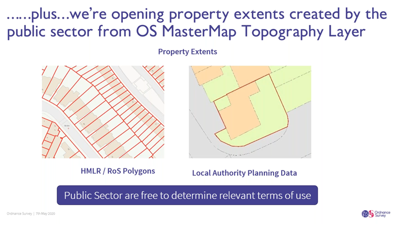
"… we will enable the public sector to release property extents that have been created from MasterMap Topography Layer. Now, what we mean by property extents in this context is Her Majesty's Land Registry polygons and/or Registers of Scotland, and in effect they depict some legal context associated with those polygons, but we also mean local authority planning data. Now again, it doesn't depict individual boundaries of properties by individual building but it does give you an extent.
"Now the key point here to note is that Ordnance Survey will now enable local authorities, HMLR, and RoS to publish this data free of any Ordnance Survey terms and free of any OS royalties. However it is for the public sector, it is for the local authorities, it is for HMLR, it is for RoS, to determine what terms of use they adopt. So they can release under the terms of an Open Government Licence, but they don't have to release it under the terms of an Open Government Licence.
"So when we talk about we're enabling, we're opening up property extents, it means we Ordnance Survey will allow the public sector to release more derived data. What Ordnance Survey isn't insisting on is whether they do so under the terms of Open Government Licence or any other terms. It is ultimately at the public sector member's discretion as to which terms they elect to make this data available. It is also up to the public sector member to determine how they make the data available and when.
"None of those issues are influenced by Ordnance Survey. They have full autonomy to decide how they wish to release it. What Ordnance Survey has done is enabled that release by saying Ordnance Survey doesn't expect any terms and conditions to be flowed through, and neither does Ordnance Survey expect any monies to be collected for Ordnance Survey."
I don't know what OS is telling HMLR and other PSGA members about property extents.
But let us take the above at face value and assume that, despite opposing an open release of the INSPIRE Index Polygons for nearly ten years, Ordnance Survey is now taking a neutral stance on whether Land Registry publishes the polygons under OGL.
How would that actually work from a licensing point of view?
The new policy on property extents is presented as an extension to OS's existing "presumption to publish" process. The FAQ links to its "simple publishing criteria" for derived data.
Those publishing criteria include a requirement that the data must be published under the Open Government Licence.
Land Registry's current use of OS data to create and publish the INSPIRE Index Polygons is not based on the presumption to publish process, nor indeed on Land Registry's membership of the PSGA. It's a bespoke arrangement made (under pressure from Government) to ensure compliance with the EU's INSPIRE Directive.
If Ordnance Survey will allow derived data to be published in property extents under any terms, not only the OGL, the explanation of that policy on the OS website is misleading.
Does the position set out in the partner webinar mean OS also intends to remove the OGL requirement from the presumption to publish criteria for derived data other than in property extents? Such a move would significantly undermine OS's support for open data.
On the other hand if PSGA members will genuinely be free to determine the relevant terms of use, could a public sector organisation decide to publish OS data in property extents under an open licence that is even more permissive than the OGL, such as Microsoft's Open Use of Data Agreement (O-UDA)? Is Ordnance Survey potentially waiving the attribution requirement that appears in OGL and most, but not all, open data licences?
Another piece of the puzzle: Ordnance Survey has also said it will withdraw its Land Registry Polygon Contract from 1 July 2020.
Currently OS publishes a set of Service Terms that apply to free use of OS derived data in the INSPIRE Index Polygons.
Anyone who wants to use the polygons for a purpose other than personal non-commercial use or commercial or non-commercial use within their organisation, or to sub-license, redistribute, sell or make available the polygons to third parties, has to contact OS for an additional licence on commercial terms. That's the Land Registry Polygon Contract.
I get the impression OS doesn't do much business on the basis of the Land Registry Polygon Contract, and as far as I know the standard pricing hasn't been published.
Withdrawal of the Land Registry Polygon Contract only makes sense if Ordnance Survey already has a pretty good idea what Land Registry intends to do on end-user licensing of the INSPIRE Index Polygons from July.
As far as I can see, Land Registry has four options on licensing of the INSPIRE Index Polygons from 1 July 2020.
First, Land Registry can avail itself of the "new freedoms" and notify Ordnance Survey that it intends to release the full dataset under the Open Government Licence.
That option will displease many of OS's distribution partners. However by professing neutrality on this decision OS can deflect all blame towards Land Registry.
Second, Land Registry can apply a more restrictive licence to the full dataset, such as the EU INSPIRE End User Licence or the Public Sector End User Licence.
That option will alienate the UK's burgeoning open geospatial community and make Land Registry's "open approach to data" look like empty rhetoric. However by professing neutrality on this decision OS can deflect all blame towards Land Registry. (See how that works?)
Third, Land Registry can withdraw the dataset from publication and stop producing the INSPIRE polygons.
That option is unlikely in the foreseeable future, because publication of cadastral boundaries in some form will remain a legal requirement at least until the UK leaves the EU at the end of 2020 (and probably longer).
Fourth, Land Registry could simply do nothing. Technically it isn't obliged to clear OS's third party rights in the dataset – it could just keep referring users back to Ordnance Survey for terms.
That option will annoy everybody but might force Ordnance Survey to take an affirmative position on licensing of the polygons, because under regulations on public sector information it cannot simply refuse to offer terms for re-use of information.
(Of course the last option is really just a flight of fancy on my part, as it only makes sense in an outlandish scenario where Land Registry and Ordnance Survey are engaged in some kind of under-supervised intragovernmental pissing contest.)
On balance the most plausible outcome is that Land Registry will finally release the INSPIRE Index Polygons as open data. But we should not take that for granted. OS and Land Registry have both reneged on open data commitments in the past.
There may be legal recourse available if Land Registry does not open the polygons. Data users cannot compel Land Registry to exercise Ordnance Survey's new freedoms for PSGA members on sharing of property extents. However if challenged under PSI regulations the removal of OS objections to release of the dataset under the Open Government Licence would make it difficult for Land Registry to justify any more restrictive terms.