Ordnance Survey has cancelled a plan to release property extents created from the OS MasterMap Topography Layer as open data.
Instead OS will give other public sector organisations "new freedoms" to publish their own property extents data under the Open Government Licence even if those extents are derived from features in MasterMap.
The OS release of property extents was promised by Cabinet Office in June 2018 as the top item on a list of measures intended to unlock government's mapping and location data and boost the economy by £130m a year.
Opening up OS MasterMap was announced as one of the first projects to be delivered by the Cabinet Office's new Geospatial Commission unit.
Nearly two years later, no data has been released.
However last month OS and the Cabinet Office said that some changes to licensing of MasterMap data would be implemented from 1 July 2020. This includes the launch of new OGL datasets containing core identifiers used in MasterMap (UPRNs, USRNs, and TOIDs).
Cancellation of the property extents dataset is explained in an update on the Ordnance Survey website:
Why isn't OS publishing a property extent dataset under OGL terms?
OS MasterMap Topography Layer shows the physical features on the ground at the time of survey, it never shows legal property boundaries, nor does it show ownership of physical features.
The vast majority of feedback received during engagement with the geospatial industry on this element of the Open MasterMap policy, stated that OS releasing a property extent dataset under OGL terms would cause confusion and be likely to lead to misuse of the data, for example, in the high value use case of conveyancing. This was due to the likelihood that it would be seen as authoritative, but would have no basis as such. The Geospatial Commission decided that OS should not release a property extents dataset under OGL, but deliver this element of the policy by removing OS restrictions on PSGA members publishing their authoritative data under these terms.
This change of approach raises a number of questions.
There is some truth to the argument that OS cannot technically create property extents from MasterMap.
OS MasterMap is the most detailed digital map of Great Britain currently available in the geospatial market, but does not contain any information on the legal ownership of land or property. That information is mainly held in official registers maintained by the HM Land Registry for England and Wales and by the Registers of Scotland.
Title plans registered with HMLR and RoS include a general representation of the property's legal boundary, which is available in digital format as a polygon (for a fee). Boundaries are defined by making reference to features in the OS MasterMap Topography Layer.
For more information on this relationship see the OS explainer on property boundaries and HMLR's guidance on title plans and boundaries.
Although the property extents data held by HMLR and RoS includes data derived from MasterMap, Ordnance Survey does not maintain a record of every feature in MasterMap used for that purpose – and ownership boundaries do not always follow MasterMap features. This means release of those authoritative property extents for Great Britain as open data would require collaborative action by all three public bodies.
Then why did the Cabinet Office say OS would release property extents created from MasterMap?
In June 2018 the Geospatial Commission was a new unit and had not fully engaged with the geospatial industry.
However MasterMap is a mature product, and we know the Cabinet Office paid the Boston Consulting Group £1.7 million for consultancy on MasterMap options before making the 2018 announcement.
It is implausible that the Cabinet Office didn't understand the limitations of MasterMap in 2018, or that it took two years for OS to understand the practical difficulties of separating out the relevant data from MasterMap.
Does the geospatial industry have valid concerns about misuse and confusion if property extents are released under OGL?
This depends on who we mean by the geospatial industry.
The Open MasterMap Implementation Programme has benefited from the advice of members of Ordnance Survey's Customer Advisory Group. Most of the industry members of the CAG seem to be value-added resellers of OS premium data.
One of the drawbacks of relying on industry feedback rather than public consultation is that vested interests will rarely argue for disruption of their business models.
I'm not quite sure how open release of a subset of the Topography Layer would create confusion of authority in the market, given that "Topo" is OS's most detailed level of mapping and the same data is already used in HMLR and RoS polygons. A defining characteristics of open data is that it is not necessarily warranted as suitable for any specific purpose – as with any dataset, authority depends on how the dataset is created and presented at publication.
No doubt it is important to protect the "high value use case" of conveyancing from misuse of data. None of us want to see armchair conveyancers drawing their own ownership boundaries all over the place. But Ordnance Survey could have reduced potential for confusion by releasing the relevant data from MasterMap without calling it a "property extents" datasets.
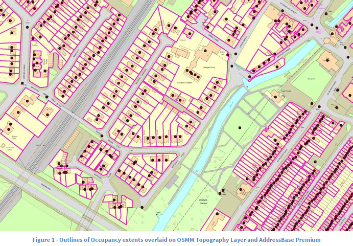
At one point OS did seem to be considering this option. In late 2018 participants in an OS trial were asked to assess the viability of an "occupancy extents" dataset, composed of polygons that were automatically inferred from MasterMap features and designed to indicate land use or purpose. In my view that occupancy extents dataset would have been welcomed by data users as useful for open visualisation of land use and detailed thematic mapping.
Is giving public sector organisations "new freedoms" to share OS data a better approach?
Ordnance Survey has said that from 1 July 2020 organisations covered by the Public Sector Geospatial Agreement will be able to publish property extents they have created from OS MasterMap Topography Layer under Open Government Licence terms.
For purposes of this policy, property extents data consists of "closed polygons representing real-world features such as fences and walls, or non-real-world features such as where a driveway meets a pavement."
Based on OS's current explanation there are significant limitations and ambiguities in the new freedoms to share property extents data. For example OS asks that organisations do not "create a situation where a full detailed building footprint can be back-engineered from the data you release."
There are problems with this policy as a general approach that will deliver open data.
OS is effectively extending its existing "presumption to publish" process, which puts the onus on PSGA members to judge whether their proposed release of open data meets OS's criteria.
Based on past experience, presumption to publish is not a strategic approach to unlocking data on a national scale unless there is also a policy driver from central government.
For example, all local planning authorities in England are permitted to release their spatial data on public rights of way proactively under presumption to publish. But in practice most of the PROW data we have so far has been unlocked piecemeal through years of perseverance by a small number of campaigners.
Giving PSGA members the "freedom" to publish OS derived data is no substitute for publication of open data by Ordnance Survey itself, because there is an incentive gap. The public can sometimes compel release of open data under the Re-use of Public Sector Information Regulations. However it is not clear that PSI regulations can be used either to compel a PSGA member to clear third-party rights in their data, or to compel OS to grant those rights in the absence of a request from the PSGA member.
But surely now HM Land Registry and Registers of Scotland will unlock their property extents data?
Currently there are no open national datasets for parcel-level property and land boundaries in Britain.
There are two free-to-use datasets available: Land Registry's INSPIRE Index Polygons for England and Wales, and RoS's INSPIRE Cadastral Parcels, both published to comply with a European Union directive on sharing of spatial data infrastructure.
However neither INSPIRE dataset is licensed for re-use as open data – the usual excuse given is that the polygons are derived from data in Ordnance Survey's MasterMap. Anyone who wants to use the INSPIRE polygons for most commercial purposes, or distribute the data (which includes most publication on the web), has to agree separate terms with Ordnance Survey.
From July that additional OS licensing requirement is going away. OS has told commercial partners in recent webinars that its Land Registry Polygon contract will be withdrawn.
OS has also specifically mentioned the two INSPIRE polygon datasets as examples of property extents that could then be published under the OGL.
However there has been a conspicious lack of confirmation from Land Registry and RoS that they intend to take advantage of OS's new freedoms to share data. Land Registry, like Ordnance Survey, is nominally under the oversight of the Geospatial Commission. If the Cabinet Office is confident that OS's licensing changes clear the way for release of the INSPIRE polygons, why didn't the GC announce that last month?
In theory all Land Registry needs to do to make its INSPIRE Index Polygons open data is notify Ordnance Survey and remove the OS licensing caveats from its conditions of use.
RoS's position is harder to judge because it is more remote from the influence of Cabinet Office policy, and because its own rights in the INSPIRE Cadastral Parcels are currently licensed under an INSPIRE Agreement rather than the OGL.
Are INSPIRE polygons just a distraction?
Many users of UK geospatial data are keen to see the release of Land Registry's INSPIRE Index Polygons as open data. The Open Data User Group recommended release of this dataset as far back as 2013. The INSPIRE polygons have untapped potential for visualising land parcels on the web, and their current status as "free but not open" data makes that potential seem tantalisingly close.
However we should remember that Land Registry only started publishing the INSPIRE dataset for the purpose of grudging and minimal compliance with EU rules. The INSPIRE Index Polygons only cover freehold registered properties, and are a subset of the more authoritative National Polygon Dataset.
INSPIRE polygons are not even attributed with title numbers – instead Land Registry created "Land Registry-INSPIRE IDs" that have to be entered individually into a web form to get the corresponding title information.
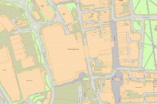
This is a picture of some data from the OS MasterMap Topography Layer:
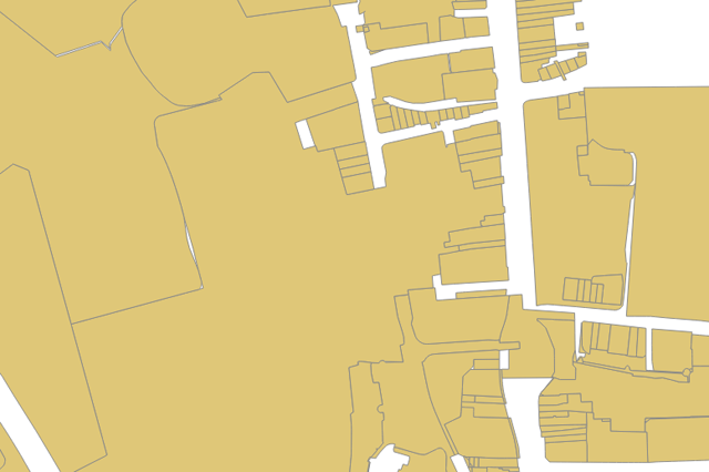
And this is a picture of unstyled INSPIRE Index Polygons in the same area:
We should expect more from Land Registry than release of the INSPIRE Index Polygons as open data.
Land Registry is no longer a trading fund and, unlike Ordnance Survey, is not obliged to pursue commercial revenue. The vast majority of Land Registry's income is from fees for registration services and land searches, and commercial licensing of register data is a relatively minor source of revenue.
I hope Land Registry will unlock the INSPIRE polygons in July once the new OS policy on property extents takes effect. However this should be a stopgap measure. The UK is expected to leave the European Union at the end of 2020, and we cannot be sure how long the UK Government will continue to align with INSPIRE requirements.
Land Registry should also move quickly to release the three National Polygon Service datasets under the Open Government Licence. Those datasets are a more complete source of property extents data for England and Wales, and releasing them as open data will ensure they maintain their authority in a wider range of applications.