Post: 8 March 2015
Update: 13 February 2017. Environment Agency has today released a new open dataset Flood warning system registration figures that contains a more recent version of the data discussed in this post.
Update: 24 March 2015. The zip file linked below now includes an additional spreadsheet with figures to 9 March 2015.
The Environment Agency Data Advisory Group (EADAG) meets for the third time this week, and papers from previous meetings have been published on a new blog.
One of things the group has been doing is commenting on a list of 50 datasets that EA have prioritised for consideration as open data releases. (LiDAR data came out on top.)
EA’s list is mostly sensible but there are some notable omissions, such as the Historic Landfill and Environmental Pollution Incidents datasets. EA have more than 1,300 identified data assets, and they have to start somewhere. However we need to make sure decisions on what to release are guided mainly by the potential to maximise re-use of public data.
Floodline Warnings Direct
I would also like to explore the potential for open data release of small-area statistics on registrations for EA’s Floodline Warnings Direct (FWD) service. There is likely to be a market for re-use of this data, for example in insurance and by flood action groups. There is also an argument that release would dovetail with EA’s corporate objectives by publicising the availability of the service.
EA have recently sent me their most recent monthly report on FWD registrations, following an information request. You can download a zip file containing the spreadsheets and correspondence. Please take note of the Standard Notice i.e. that this is not open data.
(Update: the zip file linked above now includes an additional spreadsheet with figures to 9 March 2015. The remainder of this post is based on the original February 2015 figures.)
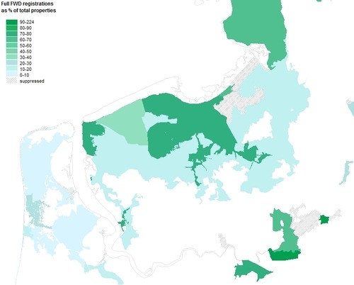
The figures are based on “Target Areas”, which include all Flood Warning Areas, and some Flood Alert Areas. The report provides the total number of properties in each Target Area, the number of full FWD registrations, and the number of properties where EA have been able to obtain a contact number via Extended Direct Warnings, a datasharing arrangement with telephone companies.
Polygons for Flood Warning Areas and Flood Alert Areas are already available as open data, which means we can map the number of FWD registrations as a percentage of total properties:
There are several caveats to the data, however. Some Target Areas overlap, so a property may be included in the figures for more than one area. Some properties have been registered more than once in the same Target Area; for example, a tenant and a landlord could both sign up to receive warnings about the same property.
EA have also suppressed the data for any Target Area with less than 25 properties, to “protect the anonymity of customers”. EA treats the fact of whether a property is registered with the Floodline service as personal data, even without any details on who registered to receive the warning. I’m not particularly convinced that really is personal data, given that numerous individuals (and companies) may have an interest in registering to receive warnings about a particular property. However EA’s approach is part of a wider trend towards treating property information as personal.
How popular is the FWD service?
EA’s Corporate Scorecard includes a national target for the percentage of total properties at high risk of flooding that can receive direct warnings. The actual figure was at 57% in Q4 FY 2013-14.
Given the caveats above it’s a bit difficult to calculate an overall figure from the monthly report, but it looks as if between 19% and 24% of total properties in Target Areas are fully registered to FWD. Perhaps less if the level of duplicate registrations is significant.
That suggests take-up of the service is much higher in Target Areas where a lot of properties are at high risk of flooding, which obviously makes sense.
(I will probably submit a second information request for statistics specifically related to high risk properties. I missed a trick by not asking for that originally.)
Open data
As EA are already producing these figures on a monthly basis, it seems to me that there is a good argument for tidying them up a bit and publishing them as open data. (Perhaps quarterly, to allow for quality assurance.)
As spatial data for the Target Areas is already available, there is potential to map and monitor take-up of the FWD service in local areas and analyse it in comparison to other factors such as geodemographics, digital literacy, past flood events, locations of flood action groups, etc. Any such re-use would raise awareness of the FWD service and encourage more people to register.
Note: The above is based mainly on my reading of public information about the FWD service, not on any direct involvement. Please don’t take it as an authoritative or complete explanation.
The map is based on Flood Warning Area polygons © Environment Agency copyright and/or database right 2014. All rights reserved.