Tiresomely, the First-tier Tribunal that handles information rights cases has dismissed my appeal against last year's ICO decision and upheld the Environment Agency's refusal to release data on the maxium flood extents of large raised reservoirs in England.
I've written previously about the ICO decision. I was successful in obtaining the release of point locations for the reservoirs. My FTT appeal related to an additional dataset, Reservoir Flood Map Maximum Flood Outline (Extent) (AfA113), and simplified data on flood depths and speeds that the EA uses to render its WMS layers for Risk of Flooding from Reservoirs. Those layers are also displayed on the EA's long term flood risk site.
I actually submitted two appeals, one for access under the Environmental Information Regulations 2014 and the other for re-use (as open data) under the Re-use of Public Sector Information Regulations 2015. As far as I know, this is the first time the Tribunal has received an appeal under RoPSIR 2015. However, the two appeals were combined. As the Tribunal dismissed the EIR appeal, it did not consider any of the RoPSIR arguments (or mention RoPSIR in its decision).
In dismissing my appeal, the Tribunal agreed with the Environment Agency's view that release of the data would adversely affect national security and public safety.
Below are my comments on the Tribunal decision. I have appended my grounds of appeal and submissions. Those are only one side of the arguments, of course – I understand from the Tribunal's guidance that I cannot publish the responses and submissions from the EA and ICO without their permission.
The Information Commissioner doesn't have GIS (but that's … okay?)
The kicker in the Tribunal's decision is the following remark at the end:
43. The appellant's further final submissions (11 May 2021) complain that the Commissioner was not able to view even samples of the withheld datasets, due to not having access to the relevant software. He says that the Commissioner cannot have adequately scrutinised EA's application of the exemption. We disagree. Neither this Tribunal nor the Commissioner is in a position to analyse detailed data in this way, or make our own assessment of whether or not disclosure would adversely affect national security or public safety based on viewing the detailed data itself. We have assessed the appellant's arguments and the explanations from EA, which included asking EA additional questions in order to clarify our understanding, and made our decision on this basis.
The Tribunal's position is either that it and the ICO are capable of understanding detailed geospatial data without viewing it in geospatial formats, or that it doesn't need to understand the data itself in order to assess the credibility of the public body's application of the EIR exceptions. I can't quite tell which.
As context, it's relevant to know that the combined open bundle for this appeal, compiled by the ICO on the Tribunal's instructions, was a 912-page PDF. 646 of those pages were copies of two Excel spreadsheets, of which only two rows were relevant to the appeal.
Detailed versus simplified data
It is debatable whether the data within scope of this appeal is 'detailed'. That was one of my grounds of appeal – that the ICO failed to make any real distinction between the detailed and simplified datasets when considering my complaint:
The Commissioner did not consider the minimum level of detail in his request for data on maximum flood depth and maximum flood speed. The appellant confirms that he is only appealing the decision on the minimum information he requested – he is not appealing the application of Regulation 12(5)(b) to any more detail that that. The Commissioner conflated this part of his request with a larger body of detailed technical data held by EA, and treated that body of data as indivisible. He had asked for the underlying simplified information that is used to create interactive maps which are available on the public flood warning information website. He says that these map images of simplified information about reservoir flood risk are publicly available, and so he does not think EA can sustain an argument that the underlying feature and attribute information would affect national security or public safety."
Despite that, the Tribunal starts and sticks with the proposition that my appeal relates to detailed data:
2. These appeals have a relatively complex history, but the issues to be decided by the Tribunal are now relatively narrow. In summary, the appellant requested detailed datasets about maximum flood outlines, depths and speed. EA says that this detailed information could be used to inform a terrorist attack on a reservoir, and so disclosure under EIR would endanger national security and public safety.
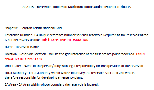
Detailed is relative, of course. The AfA113 is detailed in the sense that it includes maximum flood outlines for individual reservoirs. But the vector data that underlies the WMS layers is merged and, in the EA's own description, a "simplified version". Neither dataset is anywhere near as detailed as AfA180, the Reservoir Flood Maps – Spatial Data that the EA makes available for emergency planning purposes.
The National Protocol
The National Protocol that the Tribunal mentions in paragraph 24 has been previously released under FOI, so you can decide for yourself whether it supports the EA's arguments.
24. There is a National Protocol for the handling, transmission and storage of reservoir information and flood maps, latest version June 2018, which we have seen (the "National Protocol").
The EA did not submit any record of the advice to says it took from Cabinet Office and Defra, referenced at several points in the decision.
Detailed versus simplified data – part two
The following from paragraph 31 is the Tribunal's conclusion with respect to the Reservoir Flood Map Maximum Flood Outline (Extent) dataset (AfA113):
We accept EA's position, and find that disclosure of dataset AfA113 would include a level of detail that would endanger national security and public safety due to the risk of terrorist attack. EA have provided an explanation of their position, and we have no reason to doubt that explanation. Put simply, we accept that detailed data about how the maximum flood outline for a large reservoir has been calculated could be used by those intent on causing harm to the public in order to cause a catastrophic flood.
However, AfA113 does not contain data about how the maximum flood outline has been been calculated. It only provides an output of those calculations, a polygon for the maximum flood outline itself (along with some attributes).
I think the Tribunal might have grasped that point better if it had viewed the dataset in a GIS. But even based on the metadata submitted by the EA it should have been clear to the Tribunal that AfA113 does not show how the outlines have been calculated:
Similarly in paragraph 33:
We note that basic maps showing maximum flood outlines are available online, which goes some way towards assisting those living close to reservoirs to understand the risks of flooding. As noted by the Commissioner, the amount of information in the full dataset AfA113 is likely to go far beyond what the average member of the public would need to assess risks and/or hold reservoir undertakers to account.
Actually, what the ICO said in it's decision (paragraph 36) was:
the amount of information in the AfA113 and AfA180 datasets on flood mapping and flood speeds and depths is likely to go far beyond what the average member of the public would need to hold reservoir undertakers to account.
I didn't dispute that point in my appeal submisson, because I was not seeking the more detailed information in AfA180. Although much of the ICO's decision dealt with AfA180, that data source was only ever a matter of discussion because the EA introduced it to inflate its arguments about the public safety risk.
EA licensing retcon
Paragraph 12 in the decision summarises this Environment Agency attempt to rewrite history:
AfA134 was until recently only available in electronic format under a Conditional Licence as it contained personal details of reservoir undertakers and engineers. This has been reviewed and the dataset is publicly available with personal data redacted.
AfA134 is the dataset containing point locations of reservoirs that the ICO required it to release to me under the Open Government Licence. EA had attempted to apply restrictions on re-use due to "National Security concerns" – nothing about personal data.
That was the focus of the arguments and decision in the RoSIR complaint. At the time of my information request, the Conditional Licence restrictions advertised by the EA for AfA113 and AfA134 were identical. However, the Tribunal has taken no notice of either inconsistency.
WMS is a national security measure
Later submissions in the appeal correspondence focused on the EA's claim that publishing simplified information about reservoir flood risk as raster images through web maps and WMS layers provided protection against risks that would arise if the underlying data used to render those was published in vector formats:
37. EA agrees that the data requested by the appellant includes the same simplified information as already contained in the maps themselves. However, EA maintains that the specific format this data has been requested in is exempt from disclosure. This is because a recipient of data provided in that specific form could use it to then query and modify the data, integrating and analysing it alongside other published datasets. Combining the requested data with other data that is publicly available would enable those intent on doing harm to target sites where inundation could do most harm to both human life and the infrastructure of the country. This was the basis of the assessment made with the Cabinet Office and Defra. If information were to be released in a form that could be manipulated and combined with other information, this could inform and assist those intent on doing harm. Detailed knowledge about the speed and depth of inundation from a reservoir could be used to identify sites to target to cause maximum harm.
This summary of my counter-arguments is more or less accurate:
38. The appellant has provided a reply. He says that he has been able to download fixed images and use these to derive new feature data that can be manipulated, and so the data can be queried and modified. He agrees that the data could be used to produce a statistical analysis of the relative potential for harm from inundation from reservoirs in different locations. He argues that this would support wider public understanding and awareness of flood risk from reservoirs, and potentially be useful for other lawful purposes, such as estimates by property insurers. He argues that the risks of targeting of sites where inundation would do most harm already exist as a result of information already available, and that disclosure of the requested data would not make much difference. He refers to EA's published flood risk maps for river basin districts which include maps that mark locations where the risk to people is greatest, and other maps that highlight risks to economic activity and to the natural and historic environment.
But the Tribunal misunderstands my submissions entirely:
41. The appellant says that he has been able to derive the underlying data from the maps, and has provided a copy of a blog post which explains how this has been done. The Tribunal has not been able to assess whether this is an accurate method of obtaining the underlying data. The fact that an individual may be able to use complex methods to obtain some underlying data from published maps is very different from publication of all underlying data in an accessible format by EA. Disclosure of the requested information would still adversely affect national security and public safety, as it provides all the information in an immediately accessible and manipulable form. The appellant also refers to published flood risk maps for river basin districts, and other maps that show risk of flooding. However, this is very different from the specific risks posed by large raised reservoirs, which are built structures that are particularly vulnerable to attack by those wishing to cause harm.
To be clear, I did not at any point "derive the underlying data" from the maps. The method I described only derived new feature data from the raster images. I argued this new data could be used to perform analysis of the type that the EA claimed it was preventing by refusing to release the underlying data. However, I said explicitly that I could not accurately measure congruity without access to the underlying data.
And I highlighted the public availability of the flood risk maps for river basin districts precisely because they present an analysis of the relative scale of risk to people and economic activity from reservoir inundation at different locations – the type of analysis EA claims it is preventing by withholding the vector data underlying its public maps. I did not make any comparison to the availability of information about other types of flood risk.
Summary
¯\_(ツ)_/¯
Appellant's grounds of appeal and submissions:
- 20201117 Grounds of appeal
- 20210305 Reply to responses from ICO and EA
Attachment 1: AfA113 metadata
Attachment 2: LIT_6882 Explanatory Note on Reservoir Flood Maps - 20210319 Reply to further EA response
- 20210511 Further submissions
- 20210830 Further submission
Attachment 1: 20210404 blog post on vectorising EA reservoir flood map outline data
Attachment 2: LIT8970 Flood Risk Maps Severn Reservoirs
Epilogue, 9 November 2021
Three weeks after the Tribunal handed down its decision, the Environment Agency released updated flood extents of large raised reservoirs, in re-usable GIS data formats, under the Open Government Licence.