Post: 3 April 2018
The Office for National Statistics (ONS) publishes administrative boundaries for Great Britain in vector formats at a range of resolutions, from “full” to “ultra generalised”.
These options are helpful – users can choose the boundary dataset that best fits their needs. Full resolution boundaries are suitable for detailed analysis of location data in a desktop GIS, while generalised versions are better for thematic mapping on the web.
The full resolution boundaries are available in two versions:
The Mean Low Water and Mean High Water lines (sometimes called tidelines) used to produce ONS’s boundary datasets are also found in Ordnance Survey’s Boundary-Line product. Boundary-Line layers are cut to the Mean Low Water line, with Mean High Water supplied as a separate polyline.
Both Boundary-Line and the ONS boundary datasets are available for free re-use as open data.
But what if we need to define the coastline in more detail, for example for site planning or a local environmental assessment?
More detailed sources
The gold standard for detailed work is the OS MasterMap Topography Layer, Ordnance Survey’s most granular view of Britain’s landscape, which includes Mean Low Water and Mean High Water among many other water features.
Alternatively OS Terrain 5, Ordnance Survey’s detailed digital terrain model (DTM), includes both Mean Low Water and Mean High Water as five metre interval standard contour polylines.
However neither OS MasterMap nor OS Terrain 5 are open data. Most users have to pay for this data, and the terms are impractical for some applications.
OS Terrain 50
There is another source: OS Terrain 50, an Ordnance Survey DTM product that includes Mean Low Water and Mean High Water as 50 metre interval standard contour polylines.
That’s obviously less granular than the data in Ordnance Survey’s paid products. However the water lines in OS Terrain 50 are generally more detailed than those available in Boundary-Line or in ONS’s full resolution boundary datasets.
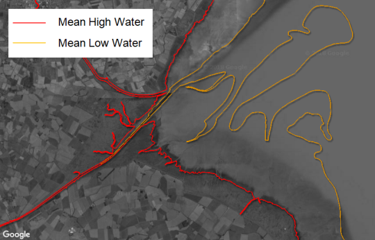
For example this is the Wash with ONS’s full extent and full clipped boundaries:
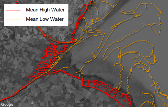
and this is the same location with water lines from OS Terrain 50:
Water Lines GB
I’ve extracted the Mean Low Water and Mean High Water polylines from the most recent release of OS Terrain 50, and collated them into two national layers as a new open data product: Water Lines GB.
This product is intended mainly as an intermediate option for users who want to cut site boundaries to the coastline, at a higher level of detail than is available from ONS’s full resolution boundaries but without getting into the derived data issues and other limitations that arise from use of Ordnance Survey’s paid products.
Image credits: Dorset Bay Sunset by Diego Torres via Pixabay (CC0); map images contain OS data © Crown copyright and database right 2017.