Update: 23 July 2017
The workaround described in this post should no longer be necessary as Land Registry has subsequently uploaded revised copies of the INSPIRE Index Polygons data.
Post: 16 July 2017
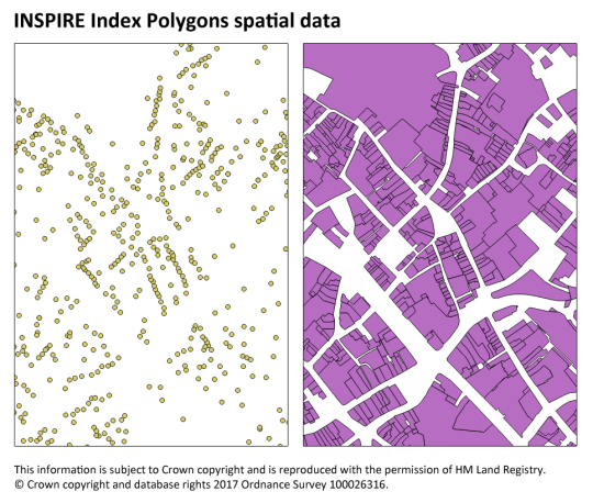
There is a technical problem with accessibility of the version of Land Registry’s INSPIRE Index Polygons currently available for download. For users who open the GML files in QGIS the polygons will likely appear, confusingly, as points.
The polygons are contained in the GML files but QGIS only displays the centroids. I understand this relates to a bug in QGIS or in GDAL, a software library used by QGIS.
The problem was identified by @guyshrubsole and investigated by @beadyallen, who has very helpfully devised a workaround:
1. Create a text file containing the xml below.
2. Save the file as Land_Registry_Cadastral_Parcels.gfs in the same folder as each GML file. (Replace the existing GFS file if necessary.)
3. Open the GML file in QGIS. The polygons should now be visible.
<GMLFeatureClassList>
  <GMLFeatureClass>
    <Name>PREDEFINED</Name>
    <ElementPath>PREDEFINED</ElementPath>
    <SRSName>urn:ogc:def:crs:EPSG::27700</SRSName>
    <PropertyDefn>
      <Name>INSPIREID</Name>
      <ElementPath>INSPIREID</ElementPath>
      <Type>Integer</Type>
    </PropertyDefn>
    <PropertyDefn>
      <Name>LABEL</Name>
      <ElementPath>LABEL</ElementPath>
      <Type>Integer</Type>
    </PropertyDefn>
    <PropertyDefn>
      <Name>NATIONALCADASTRALREFERENCE</Name>
      <ElementPath>NATIONALCADASTRALREFERENCE</ElementPath>
      <Type>Integer</Type>
    </PropertyDefn>
    <PropertyDefn>
      <Name>AREAVALUE</Name>
      <ElementPath>AREAVALUE</ElementPath>
      <Type>Real</Type>
    </PropertyDefn>
    <PropertyDefn>
      <Name>VALIDFROM</Name>
      <ElementPath>VALIDFROM</ElementPath>
      <Type>String</Type>
      <Width>24</Width>
    </PropertyDefn>
    <PropertyDefn>
      <Name>BEGINLIFESPANVERSION</Name>
      <ElementPath>BEGINLIFESPANVERSION</ElementPath>
      <Type>String</Type>
      <Width>24</Width>
    </PropertyDefn>
    <GeometryElementPath>GEOMETRY</GeometryElementPath>
    <PropertyDefn>
      <Name>REFERENCEPOINT</Name>
      <ElementPath>REFERENCEPOINT</ElementPath>
      <Type>String</Type>
      <Width>24</Width>
    </PropertyDefn>
  </GMLFeatureClass>
</GMLFeatureClassList>
Other GIS software may be able to display the polygons correctly without a workaround. However QGIS is the only free, open GIS software readily available to many users. Many or most of those users will (like me) be insufficiently familiar with GML to understand the problem without help. I hope Land Registry will take notice of this problem and issue a revised version of the INSPIRE Index Polygons.