Post: 16 September 2016
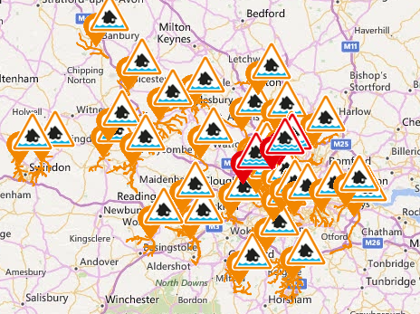
Today many places in the south of England have been thrown into chaos by flash flooding as a result of post-heatwave thunderstorms and heavy rains. This kind of volatile weather is an increasingly frequent occurrence in the UK, a trend linked to climate change.
Although heavy rain can also cause rapid rise in river levels, much flash flooding involves surface water flows in urban areas where drainage systems cannot cope with the sudden volume of rainwater. Surface water flooding often catches communities by surprise because it can occur off the natural floodplain, away from rivers and the coast.
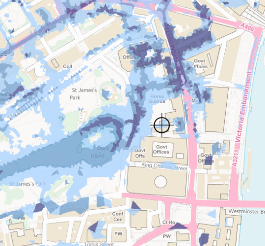
The risk of surface water flooding is more difficult to model than the risk of flooding from rivers and the sea. However the Environment Agency does have a credible national risk map, Risk of Flooding from Surface Water (RoFSW).
RoFSW is relatively new and was compiled from data provided by Lead Local Flood Authorities (LLFAs), the councils responsible for managing local sources of flooding. Drill down far enough and you can view RoFSW maps on GOV.UK, as well as on EA’s own site. GIS users can also view RoFSW via a series of WMS feeds.
However, unlike EA’s other national maps of flood risk, Risk of Flooding from Surface Water is not currently available for re-use as open data. Environment Agency had previously announced plans to release this data by May 2016 … but something has gone wrong.
I questioned this delay at the most recent meeting of the EA Data Advisory Group (EADAG). EA was reluctant to point fingers specifically. However my understanding is that some local councils are using their intellectual property rights in the source data to block open release of the national dataset.
Why would councils want to restrict the availability and re-use of data on surface water flood risk? Concerns I’ve heard in the past relate to the accuracy of the data and potential for recriminations from owners of properties in areas identified as high risk. But those concerns can be managed without restricting re-use of the data; existing information warnings make it clear that the modelling is not property-specific and, provided there is no deliberate attempt to mislead, councils are not at any real risk of legal liability.
Or councils may be wary of generating local pressure to take more action on surface water risk, if the maps are put into wider circulation. As Damian Carrington highlights in today’s Guardian, the Government’s latest National Flood Resilience Review is rather light on strategy for dealing with surface water risk.
But councils will not be able to avoid this problem. Unlike fluvial and coastal flood risk, national investment in hard defences won’t help address surface water flooding. Community awareness and property-level flood resilience are more important – and for that we need to make sure detailed information about this type of flood risk is widely available, understood by the public, and re-usable for analysis.
One of the principles in Defra’s open data strategy is that when Defra network organisations such as Environment Agency are unable to release a publicly funded dataset as open data they should explain why. I hope EA will be able to release RoFSW soon, but if it has reached an impasse with councils it should say so. The councils themselves, and the local government minister, should then explain why they are reluctant for the public to have unfettered access to data on surface water risk.
Update: 22 September 2016
Environment Agency has this week released a new flood mapping dataset, Risk of Flooding from Multiple Sources (RoFMS). However that dataset is partly derived from the RoFSW surface water risk data discussed above, and is therefore also not (yet) available for re-use as open data.
Image credits: details from GOV.UK’s flood information service map and long term flood risk information map.