Post: 25 October 2015
Last week I posted about Environment Agency’s recent release of LiDAR open data. This is an update with some additional links and resources.
Jpegs on Flickr
Following a discussion on Twitter, Environment Agency has changed the licensing of the jpegs on its Survey Open Data Flickr stream to Public Domain. This means the jpegs can be re-used without copyright restrictions.
Json metadata
In my previous post I mentioned Christopher Gutteridge’s json index of the EA LiDAR downloads. You can now also get json metadata for LiDAR data in each grid directly from EA’s download site, e.g.:
http://www.geostore.com/environment-agency/rest/product/OS_GB_10KM/ST22
Python viewer
Ian Hopkinson has written a Python tool (defra-lidar-viewer) that enables users to view the EA ASCII files as greyscale images.
Conversion to MapInfo MIG
If you’re a MapInfo user: last month Tony Pilkington posted some MapBasic code for converting EA’s ASCII files to the native MIG (MapInfo Continuous Grid) format. You may need to tinker but the code looks functional.
PowerMap for Excel
A great tutorial for Excel users from Chris Webb:
Loading English LiDAR Open Data Into Excel And Power Map Using Power Query
Chris has provided a Power Query function that does most of the work. By following the tutorial I was able to visualise EA’s 2m LiDAR DSM in Excel 2016. (I couldn’t get Power Map to handle the same data in Excel 2013, but that may have been an issue particular to my set-up.)
Houseprices.io
There’s a Leaflet slippy map implementation of EA LiDAR DSM data on the houseprices.io site.
The site seems to be the work of Penarth-based developer Owen Reynolds. There’s a related discussion in the House Price Crash forum.
Further reading
More links from Harry Wood via the OpenStreetMap wiki: English Environment Agency LIDAR.
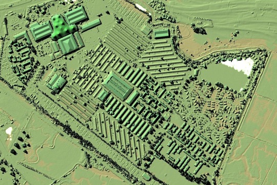
Image credit: Butlins in Minehead, a detail from SS94ne_DSM_1m by Environment Agency (Public Domain Mark 1.0)