Post: 18 October 2015
Update: 25 October 2015 – more links and resources
This is a quick post to pull together some links and resources on open aerial LiDAR data for England (and soon for other parts of the UK).
LiDAR (Light Detection And Ranging) is a remote sensing technology that measures distance by illuminating a target with a laser and analysing the reflected light. (Verbatim from Wikipedia.)
Aerial LiDAR is the acquisition of LiDAR data from aircraft (planes, helicopters and increasingly drones). See Conor Graham’s recent post for a good non-technical explanation.
(Ground-level acquisition of LiDAR data is also a rapidly growing sector, driven particularly by the emergence of self-driving vehicles, but is outside the scope of this post.)
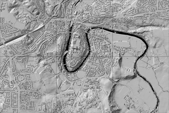
Below is a simple grayscale hillshade visualisation of some LiDAR data:
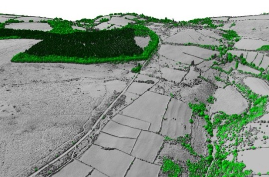
LiDAR data can also be colour-shaded and draped with aerial photographic imagery or other types of map information:
(Image credits at the bottom of this post.)
See the EA Survey Flickr stream for many more visualisations of aerial LiDAR data.
Aerial LiDAR data has applications in numerous sectors including flood risk modelling, archaeology, civil engineering, gaming, orienteering and forestry.
Environment Agency open data release
Environment Agency has been capturing aerial LiDAR data regularly since 1998 and now manages an archive of accurate elevation data for over 72% of England. EA’s LiDAR data is available at 2m, 1m, 50cm and 25cm horizontal (planar) resolutions, and supplied as both a Digital Surface Model (including heights of objects such as buildings, vehicles and vegetation) and a Digital Terrain Model (with surface objects filtered out).
In early September Environment Agency released this massive archive as open data via Data.gov.uk:
http://environment.data.gov.uk/ds/survey
There were some initial technical difficulties with the Data.gov.uk download site, but these seem to have been resolved.
See the blog post by EA’s Martin Whitworth and EA’s FAQ on the download site for more information about the release.
EA has not provided a central index of the individual data downloads but Christopher Gutteridge has recently made one in json format on GitHub. See also Gutteridge’s wiki page on ASCII LiDAR.
Martin Isenburg, who wrote a good post last year on the case for open release of national LiDAR data, has suggested EA could greatly reduce its storage and bandwidth requirements by addressing the unusually high vertical resolution of the LiDAR data in EA’s downloads. (See the comments for EA responses.)
Media coverage and blog posts
So far Environment Agency does not seem to have done much to publicise its open release of aerial LiDAR data. This is somewhat surprising given the significant re-use potential of LiDAR data and Defra’s on-going #OpenDefra programme, which has ministerial engagement.
On the other hand it has been suggested that EA is pursuing a “soft launch” strategy. There is some merit to the idea that giving the open data community a few months to play around with the data could make it easier to identify “quick wins” and produce additional examples of how the data might be used.
This week EA’s LiDAR release was covered in a Gizmodo article that focused on potential use in Minecraft. (Ordnance Survey’s open data has also been embraced by Minecrafters.)
Following are a few interesting blog posts about EA’s LiDAR release:
Lidar becomes Open-Data for England! by The Dirt Doctors
More LIDAR goodness by Chris Hill
Taking pictures with flying government lasers by Andrew Gray
Early examples of re-use
One immediate area of interest following EA’s open data release has been the potential to use aerial LiDAR to calculate building heights (the “z” coordinate missing from most geocoded property datasets). Brendan Stone has written an excellent guide to the GIS process:
How to: Extract building heights from LiDAR data and make 3D buildings
and there have been some related discussions on Open Street Map’s GB list.
Another immediate application for aerial LiDAR is 3D printing and modelling, i.e. turning LiDAR measurements into real-world objects.
Chris (Kit) Wallace, who has been using EA LiDAR data to create SLT files of his Bristol neighbourhood, recently documented his process for printing a model of Avon Gorge. And Jamie Young, who has previous experience creating 3D maps from OS terrain data, recently tweeted a picture of a 3D model of Edinburgh Castle and Princes Street Gardens created with EA open data (though I’ll admit to some confusion, as the location seems to be outside EA’s coverage *).
* Update: clarification from Jamie Young.
On the more commercial end of re-use, Landmark Information Group recently announced it would include EA’s LiDAR DTM as standard in its Envirocheck Analysis product. (See the demo.) This is a good example of how the availability of open public data can add value to commercial products through lower input costs and less burdensome licensing.
Background and economics
I haven’t seen the business case for EA’s open release of LiDAR data, but I gather it involved quite a bit of work within EA. Holland’s decision last year to open its LiDAR data may have been influential.
The Environment Agency Data Advisory Group (of which I’m a member) has been discussing EA’s plans for LiDAR data since last year. EADAG was generally supportive of open release, but it should be said that EA itself put LiDAR at the top of its list of open data candidates in a wide-ranging prioritisation exercise.
We know from information obtained by Louise Huby in November 2014 that EA’s income from commercial licensing of LiDAR data was over £200,000 a year:
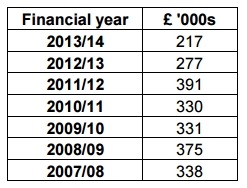
(From the above figures it appears the income was dropping off, but I’m not sure whether that was due to competition from other data providers or because of the 100% discount EA offered for non-commercial re-use.)
However this loss of income does not necessarily represent a net loss to EA from open data release of aerial LiDAR, because there are also some potential savings. EA has shut down the data ordering system on its Geomatics portal. EA has also commented that releasing LiDAR as open data could reduce the time it takes EA staff to check flood risk assessments each month, because EA will be able to specify that EA open data LiDAR must be used by third parties when completing their risk assessments.
It will be interesting to see what effect EA’s release of aerial LiDAR data will have on commercial providers (such as Bluesky and Getmapping) operating in this market, as well as on re-use of Ordnance Survey’s terrain data.
EA has assured us that open data release will not disincentivise the collection or update of better quality LiDAR data, because EA needs LiDAR for its operational purposes.
EA’s aerial LiDAR data is in many ways a good example of the classic model of open data release: useful technical data that has already been funded by the taxpayer for an essential public purpose, released for free to maximise re-use in the wider economy.
The rest of the UK
Natural Resources Wales has recently announced that aerial LiDAR data for Wales will also be released as open data, from November 2nd.
There’s a rumour that Scotland will also release its aerial LiDAR data as open data, but I have not yet been able to confirm that. (LiDAR data for Scotland was procured in a project led by Scottish Water on behalf of SEPA and the Scottish Government.) Similar I have no news on open release of LiDAR data held by the Rivers Agency for Northern Ireland.
Image credits: 1. LIDAR image of the City of Durham, 1m resolution, with buildings by Andrew Gray from Environment Agency data (OGL); 2. Lidar-forest from Environment Agency blog post (OGL).