Post: 9 January 2015
Last month Environment Agency released Risk of Flooding from Rivers and Sea (RoFRS), their core flood risk dataset for England, as open data. The dataset is now available on EA’s DataShare page as three free products: Spatial, Postcode and Property. (There’s also a WMS feed if that’s your thing.)
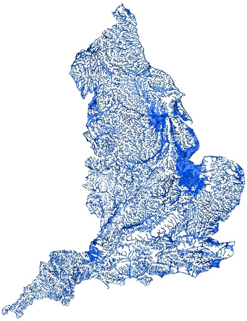
This is what the whole Spatial dataset looks like in a desktop GIS:
But the main benefit of open data release is we can now take the data off the desktop and use it on the public web. So over the holidays I experimented a bit and made some apps.
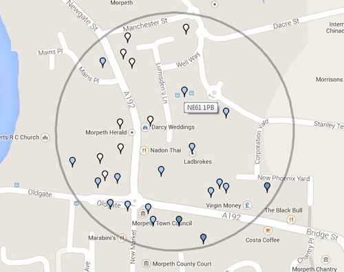
This app enables users to search the Postcode version of RoFRS by postcode or place name, and get back data about the flood risk in specific postcodes. Users can also retrieve a collection of postcodes within a radius of up to 500m. Postcode markers are colour-coded according to the highest level of risk to any property in the postcode.
The app is mainly based on the Google Maps API with a MySQL back end. I used both the ONS Postcode Directory (ONSPD) and Ordnance Survey’s Code-Point Open product to geocode the postcode-level RoFRS data.
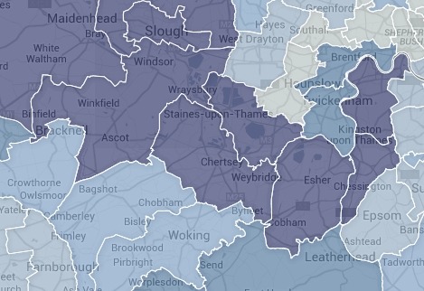
This app is also based on data from the Postcode version of RoFRS, but in this case I have aggregated the data to produce statistics for properties at various levels of risk in each parliamentary constituency. The constituencies are visualised in the Google Maps API and the user can rank the comparative risk between constituencies by selecting different criteria. The data is held in Fusion Tables.
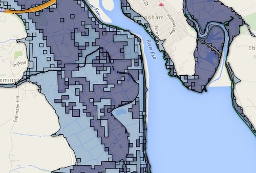
This is a subset of the Spatial version of RoFRS, again using the Google Maps API with data held in Fusion Tables. I have added layers for Flood Alert Areas and Flood Warning Areas (which are also EA open data).
I built this simple demo to test the practicality of using Fusion Tables to serve the Spatial dataset. The full dataset is quite large so I have used only the polygons within the East Devon catchment. That’s about 53 MB of KML and seems to be manageable. It might be possible to present the whole dataset by cutting it up into catchments and only presenting one or two at a time, by restricting the zoom levels at which the data is retrieved. However I will need to experiment further as there are limits on what Fusion Tables is designed to do.
What does RoFRS contain exactly?
There is documentation with the downloads. However in summary: RoFRS is an Environment Agency risk model that assesses “the likelihood of flooding from rivers and the sea at any location, based on the presence and effect of all flood defences, predicted flood levels, and ground levels.” The likelihood of flooding is assessed within 50m x 50m grid cells and put into one of four categories:
The Postcode version contains counts of properties in each of the likelihood categories, broken down as residential, non-residential and “non-addressable”. It also contains information on the number of properties that fall within a category of “significant risk” defined in the Statement of Principles, an agreement between the Association of British Insurers and the Government.
The Spatial version also contains information on the dates when particular areas were last updated, and an indicator of the spatial scale at which EA experts think the data in each area is reliable. (None of the data is reliable at the individual property level.)
The Property version contains data that, in theory, matches individual properties to the likelihood category for the grid cell in which they are located. In practice however the property location is only described as an Ordnance Survey TOID. This version of RoFRS therefore has only limited utility unless you have access to commercial OS address data.
Additional comments
I’ve used RoFRS in the past within the insurance industry (back when it was known as NaFRA) and found it very useful. Now that it has been released as open data I hope the dataset will be used more widely. I think there is substantial potential in particular for use by community flood action groups.
Environment Agency have only released RoFRS data for England. It’s unclear at the moment whether Natural Resources Wales have any plans to release their part of the RoFRS coverage as open data.
With most spatial open data there is a multiplier effect: the more datasets we have available the more useful they are in combination, both in applications and for analytic purposes. As usual with spatial data in Britain the main constraint is the availability of reference data from Ordnance Survey. I’ve written about this previously. The usefulness of RoFRS is greatly enhanced by the availability of open postcode locations (from ONS and OS). However it would be enhanced further if we also had open address locations or even boundary data for postcodes.
The images above include data from Environment Agency datasets that are, in whole or part, subject to the following attribution: “© Environment Agency copyright and/or database right 2014. All rights reserved © Crown copyright and database rights 2014 Ordnance Survey 100024198 Some features of this map are based on digital spatial data licensed from the Centre for Ecology & Hydrology, © NERC”. The ONSPD and OS Code-Point Open data and the constituency boundaries are subject to the following attribution: “Contains Ordnance Survey data © Crown copyright and database right 2014; Contains Royal Mail data © Royal Mail copyright and database right 2014; Contains National Statistics data © Crown copyright and database right 2014”. The map data is “© 2015 Google”.