Post: 22 December 2014
Earlier this month Environment Agency released their Risk of Flooding from Rivers and the Sea (RoFRS) datasets, previously known as NaFRA, as open data.
RoFRS is EA’s core national flood risk model. I will blog about these datasets in more detail in future, but basically this is (in my view at least) EA’s most significant open data release to date.
There was some comment, both online and in last week’s meeting of the EA Data Advisory Group, about the formats in which the datasets were released. In particular the spatial dataset was released as an Esri File Geodatabase, which presented some difficulty for potential re-users.
However EA have now confirmed the spatial dataset will shortly be available in multiple formats via their DataShare service. In the meantime EA have provided links to additional downloads in GML, GeoJSON, Shapefile and MapInfo TAB formats.
For convenience all of the links are below.
RoFRS - Spatial:
RoFRS - Postcodes in Areas of Risk:
RoFRS - Properties in Areas of Risk:
Many thanks to the EA data team (@dataenvagency) for all their work on this.
What, no KML ;-)? *
* Update: Believe it or not, KML!
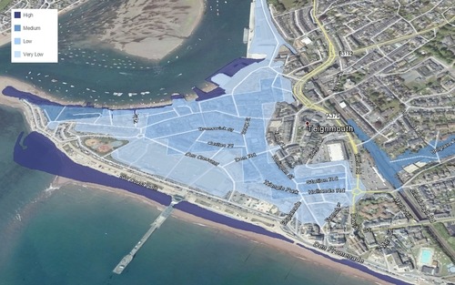
Image: Some RoFRS spatial data in Google Earth. RoFRS data re-used under the Open Government Licence. Attribution: © Environment Agency copyright and/or database right 2013. All rights reserved © Crown copyright and database rights 2013 Ordnance Survey 100024198 Some features of this map are based on digital spatial data licensed from the Centre for Ecology & Hydrology, © NERC