Post: 10 October 2014
The Department for Communities and Local Government has released Green Belt boundaries for England as a polygon dataset, for re-use under an open data licence.
The dataset may be downloaded in shapefile format from the OpenDataCommunities website.
I've written previously about the arguments for open data release of this dataset, as has Alasdair Rae of the University of Sheffield.
Another version of DCLG’s Green Belt dataset has been in circulation since 2012 when it was published on the Telegraph website. However yesterday’s release is the first time DCLG has officially made a Green Belt dataset available on open data terms.*
* Update: Jeni Tennison points out that this dataset is also available via a link from a Data.gov.uk catalogue record. The link seems to have been added in May or June.
The national Green Belt dataset is compiled from spatial data provided to DCLG by local planning authorities. (Earlier this week DCLG published new planning guidance on green belt boundaries.)
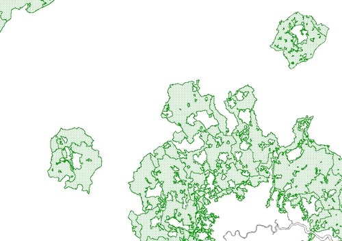
I’ve had a quick look at the data. Following are some notes:
Update: Alasdair Rae has produced an experimental web map using the Green Belt dataset.
* Update 16 October 2014: Statistics for 2013-14 have now also been published.
* Update 28 October 2014: The 2011-12 Green Belt shapefile now seems to have been replaced by a 2013-14 version on the OpenDataCommunities page.
Image credit: Produced from the dataset discussed above. © Department for Communities and Local Government. Contains Ordnance Survey data © Crown copyright and database right 2012.