Post: 1 August 2014
Yesterday the Environment Agency added some additional open data releases to its Datashare page. These datasets are reusable under the Open Government Licence.
River and Coastal Maintenance Programme
This download contains two spreadsheets, one describing the EA’s “Frequent” maintenance programme and the other its “Intermittent” maintenance programme. These programmes are about managing flood and coastal erosion risk.
Several comments:
1. Although the download page and spreadsheet names indicate this data relates to the 2013/14 programmes, I think it is actually forward-looking and relates to activities planned for the 2014/15 year. The Intermittent spreadsheet is titled “Intermittent Maintenance 2014/15”. I have asked EA to clarify.
2. EA has only released spreadsheet data, and not the spatial data for the Flood Risk Management System areas to which the data applies. I have obtained a copy of the spatial data (see my post from February) but the EA released that under its more restrictive “EA OpenData” terms, which are not fully compliant with the Open Definition. Ideally I would like to see the FRMS polygons released under the OGL (or the OS OpenData Licence, if they contain OS derived data).
3. EA has published the spreadsheets in the closed XLSX format. In line with the Government’s push to adopt open standards it would be better to use a format that is directly supported by free software, such as XLS or ODS. That said, XLSX is an improvement on releasing the data only in a 33MB XLSM file.
4. I note the spreadsheets omit the Flood Defence Grant in Aid amounts allocated for each watercourse/asset. I think EA should try to be transparent about those figures; both Defra and to a lesser extent EA itself have been criticised in the past for obfuscating the amounts spend on flood protection.
River Habitat Surveys - Survey Details and Summary Results
This is a large spreadsheet. The dataset is described on Data.gov.uk as follows:
River Habitat Survey (RHS) is the Environment Agency standard for collecting data on the physical character and quality of river habitats across the UK. It is a substantial dataset of significant research interest. RHS is a standard field survey of a 500m stretch of river where data is collected in a replicable manner. At 50m intervals a spot-check is conducted to record specific details about bank and channel physical attributes, man-made modifications, land uses and vegetation structure. Since 1994 approximately 24,000 surveys have been carried out. The bulk of surveys were carried out between 1994 to 1997 and 2006 to 2008. Surveys are still carried out for specific drivers, for example assessing habitat availability and Water Framework Directive.
I haven’t explored this dataset in any detail but it looks interesting.
See the AfA286 metadata in EA’s Information for Re-Use Register for more technical details.
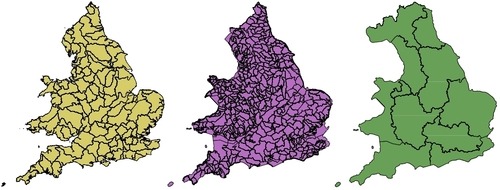
Water Framework Directive datasets
EA has also released three new WFD spatial datasets.
WFD - Management Catchments Cycle 2 (Draft) is described as follows:
Management Catchments are the geographical units for which action plans are drafted in implementing the Water Framework Directive (WFD). Catchments have an action plan published that relates to all waterbodies that fall within its boundaries.
WFD - Operational Catchments Cycle 2 (Draft) is described as follows:
Operational Catchments (Cycle 2) show how Water Framework Directive (WFD) work is grouped geographically for practical management purposes.
WFD - River Basin Districts Cycle 2 (Draft) is described as follows:
River Basin Districts are the geographical units showing the area of land and sea, made up of one or more neighbouring river basins together with their associated groundwaters and coastal waters for assessment and action under the Water Framework Directive (WFD).
I confess I have difficulty keeping track of the differences between all the WFD spatial data. Of course it’s better to have too many datasets than too few; only a few years ago it was difficult to find any open spatial data that provided a hydrologically significant segmentation of the country.
For purposes of practical reuse, however, its worth noting that the three datasets above are at a more general level of geography than the WFD - River Waterbody Catchments Cycle 2 (Draft) dataset, previously released by the EA as open data.
Recorded Flood Outlines (not released)
There have been some hints online that EA is preparing to release its Recorded Flood Outlines dataset as open data.
This spatial dataset, previously known as Historic Flood Outlines, contains the individual location outlines and approved attributes for records of historic flooding. See the AfA008 metadata in EA’s Information for Re-Use Register for more technical details.
Recorded Flood Outlines has substantially more potential for reuse than the more “niche” datasets mentioned above. I have worked with this dataset previously in a commercial context, and am quite looking forward to its release as open data. However it’s understandable that there might be some protracted discussions within the EA prior to making the data available to the general public.
Image produced from the WFD datasets described above. Attribution: “Contains Environment Agency information © Environment Agency and database right”.