Post: 27 November 2013
Back in August I submitted information requests to two English councils for copies of their Public Rights of Way mapping data.
The councils were selected on the basis that they each allow the public to view a map of their PRoW network on the web, but had also refused previous requests (from another applicant) for open data release of the underlying dataset.
My information requests were identically worded. In both cases I asked for a licence to re-use the data, in addition to access rights under the Freedom of Information Act and/or the Environmental Information Regulations.
I have covered the response from North Yorkshire Council in a previous post, and have now updated that post with additional correspondence from the internal review stage. North Yorkshire is continuing to maintain that the data is “reasonably accessible” to me on their website, and is refusing to release the underlying PRoW dataset.
The response from Buckinghamshire County Council could not have been more different.
I did have to push through to the internal review stage to resolve some side issues with the initial handling of my request. However reason prevailed, and the Council agreed to provide a copy of the dataset under EIR.
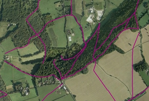
In addition the Council decided to submit an application to Ordnance Survey so that they could clear the dataset for re-use as open data. (Like most local authority PRoW mapping, Buckinghamshire’s dataset contains information derived from OS products.)
Yesterday the Council released the dataset to me with a copy of the OS OpenData Licence. You can download the dataset here:
[see also the update at the end of this post]
If you’re not familiar with Public Rights of Way information you should do some background reading before making use of the dataset. Barry Cornelius’s Rowmaps website is a good place to start. In particular you should not treat the above dataset as authoritative for any legal or planning purpose.
What are the learning points from this exercise?
Although FOI and EIR do not provide any enforceable rights to open data release of datasets held by public authorities, they can be an effective way to highlight demand for open data. If an authority has data they are willing in principle to release, a FOI/EIR request can encourage them to expedite the practicalities.
Information requests, particularly when they go to the internal review stage, are an administrative burden for public authorities. While I do not want to overstate the potential of open data to reduce FOI/EIR costs, public authorities will sometimes recognise that open data release enables them to avoid the inconvenience of repeated requests for the same information.
Because open data is not yet an enforceable right, the potential for release still depends very much on the engagement of individuals. I think that is the main reason for the contrast in the responses I received from the two councils. My request to Buckinghamshire got through to somebody who was in a position to help, and my request to North Yorkshire didn’t.
That said, practitioners involved in the handling of FOI/EIR requests rarely have a vested interest in refusing to release data under an open licence. If a public authority is consistently resistant to open re-use of public data, that’s a deliberate policy decision and/or a failing at the executive level.
For PRoW data specifically, we need a better process. Even with cooperation it took me three months to obtain Buckinghamshire’s dataset. So far about 70 councils have released their PRoW data under an open licence, but there are many who have not.
It has now been two years since the Cabinet Office announced that Ordnance Survey had “committed to amend its derived data restrictions on Local Authorities’ "Public Rights of Way” data, enabling this to be released more easily as Open Data.“ So why do councils still have to apply to Ordnance Survey for the exemptions necessary to release their data? Why do we still need to request this data from councils individually?
It’s time for a central body (whether it’s Ordnance Survey, or DCLG, or the LGA, or even the Local Public Data Panel) to take the initiative and hammer out a protocol for nationwide release of Public Rights of Way open data.
Update 6 January 2014
Buckinghamshire CC have now also made their PRoW open data available as a download from their website. This is the best source for the data as it is likely to provide the most recent version available.