Post: 29 August 2012
Why is there no open national map of Public Rights of Way in England and Wales? Or to put the question another way, why isn’t the information that local councils maintain on Public Rights of Way freely available for re-use?
This post is specifically about open data release of vector mapping data for Public Rights of Way (PRoW) maintained by local surveying authorities. The statutory basis and policy background to PRoW information is quite complicated so I’m only going to sketch it in. However there are some links at the end of the post if you want to read into the subject further.
Surveying authorities
In England and Wales public rights of way are routes on which the public has a legally protected right to pass, on foot and sometimes by other modes of travel as well.
Surveying authorities (usually county councils or unitary authorities) are required by law to maintain a Definitive Map of public rights of way in their local areas. Each right of way also has a written description called a Definitive Statement.
Definitive Maps have always been available to the public for inspection at local offices of surveying authorities. However these days most authorities also put their PRoW information on the web. Some deliver this information via interactive mapping applications, others simply as raster maps or in PDF documents.
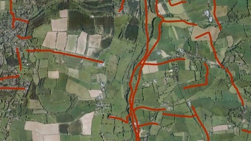
Whether on paper or online, surveying authorities usually present their Definitive Map information on Ordnance Survey background mapping.
Keeping Definitive Maps up to data is an area of considerable activity for surveying authorities. There is an ongoing effort to capture all unrecorded footpaths and bridleways created before 1949, because the Countryside and Rights of Way Act 2000 mandates that these cannot be recorded after 2025. DeFRA has recently consulted on new proposals to modernise the recording of rights of way.
Ordnance Survey use of PRoW data
Ordnance Survey began to add rights of way information to its maps back in 1960. Rights of way are now consistently shown on Ordnance Survey 1:25,000 (Explorer) maps and 1:50,000 (Landranger) maps, and in OS digital raster mapping products of equivalent or larger scale.
Although surveying authorities provide their PRoW information to Ordnance Survey for use on its maps, the Definitive Map and Definitive Statements held locally remain the authoritative record for statutory purposes.
When the previous Government prevailed upon Ordnance Survey to release its OS OpenData suite of products in April 2010, one of the main grumbles raised by digital mapping enthusiasts was the failure to include any Public Rights of Way data.
There was an excellent discussion of this issue on the Ordnance Survey’s blog at the time, in which Ordnance Survey staff did a very good job explaining the related problems.
Intellectual property rights and the derived data issue
In a nutshell there were two barriers. First, the main IP rights for Definitive Map data are held by the local surveying authorities, because they originate it and have statutory responsibility to maintain it. Second, most (and quite possibly all) surveying authorities prepare their Definitive Map by drawing over features on Ordnance Survey maps. This makes some of the PRoW information “derived data” that relies on sub-licensing of Ordnance Survey’s IP rights.
The upshot was that back in 2010 neither Ordnance Survey nor the surveying authorities were in a position to release PRoW mapping data for open re-use. However there was at least an awareness of public interest in open re-use of the data.
The 2011 Autumn Statement
Last year the Government’s Autumn Statement included a number of open data measures promoted by the Cabinet Office. One of these was a note that “Ordnance Survey has committed to amend its derived data restrictions on Local Authorities’ Public Rights of Way data, enabling this to be released more easily as Open Data.”
This implicitly put the onus on local authorities to release the data, once Ordnance Survey had cleared the way. This was one of two policy approaches the Cabinet Office could have taken. The other would have been to secure a collective commitment from local authorities to allow Ordnance Survey to release its own processed version of their data.
Ordnance Survey itself hasn’t made any public statement on how it has implemented the Autumn Statement commitment. However I gather from online discussions that it has been telling any local council inhibited by the derived data issue that they are now free to release their Definitive Map data for re-use under the OS OpenData Licence.
The OS OpenData Licence is the same licence that applies to Ordnance Survey’s own OpenData products. It basically incorporates the Open Government Licence (OGL) with additional attribution requirements to acknowledge Ordnance Survey as source of some of the data.
Recent open data releases of PRoW vector data
That’s basically where we are today. In principle the derived data issue is no longer a barrier. Any surveying authority that holds its PRoW Definitive Map as digitised vector data can simply provide that data as a download on its website.
The problem is that very few have done so. Honourable exceptions are Hampshire County Council and Devon County Council, both of which provide their data as downloads in KML and ESRI Shapefile formats. Hampshire specifies the OS OpenData Licence; clarification from Devon on licensing is pending but it’s reasonable to assume they will take the same line. Additionally Worcestershire County Council’s vector data is re-usable via WMS, also under the OS OpenData Licence.
UK volunteers who work on OpenStreetMap are keen to add PRoW vector map to their grand project, so long as the licensing can be properly cleared and documented. The OpenStreetMap Wiki includes a table of surveying authorities with notes on their view services and on availability for re-use of the Definitive Maps and Definitive Statements. (I am grateful to Rob Nickerson for bringing this to my attention.)
However OSM has exacting standards, and represents only one potential type of re-use for the PRoW vector data. Clearly an approach based on engaging with surveying authorities individually is going to be slow going.
Next steps - where’s the follow-through?
If we want a comprehensive release of Public Rights of Way open data within the life of the current Government it’s going to require a push from the centre.
As I’ve remarked before, Francis Maude et al in the Cabinet Office seem to be better at making policy announcements on open data than they are on the mechanics of delivery. However I would hope PRoW data is an issue that would fit well on the agenda of the new Open Data User Group.
As PRoW data is not separately productised by Ordnance Survey, and surveying authorities don’t seem to be deriving significant revenue from it, there should be no vested interests to undermine the business case for wider open data release.
Ideally I would like to see Ordnance Survey release the vector data it holds for Public Rights of Way either as a new product in its OS OpenData suite or as an enhancement to OS VectorMap District. This version of the data might not be “authoritative” to the standard of surveying authorities; but then the point of open data release is to maximise re-use of a data set for additional purposes rather than use for its original purpose.
The real practical question is whether Ordnance Survey actually holds PRoW data with full coverage in vector format. Back in April 2010 there were reportedly still some gaps.
My hope is that Ordnance Survey already maintains a discrete PRoW data set for its own production purposes. There is always a limit to how much additional preparatory work we can reasonably expect a public body to do in support of an open data release.
At the same time PRoW data is an issue that the Local Public Data Panel could perhaps take up. The LPDP could encourage more local authorities to release the data themselves, perhaps with best practice guidance. It could also organise local consents for Ordnance Survey to release the national data set, with suitable attribution of surveying authority copyrights.
_____________________________________________________
Update (Aug 29): PSMA Exemption Process
Steven Campbell, Chair of the PSMA User Group, has pointed out that the Public Sector Mapping Agreement includes a formal exemption process, under which PSMA members can ask the Ordnance Survey for permission to release derived data under either OS OpenData or Free to Use terms.
There’s a detailed guide to PSMA arrangements on the Ordnance Survey website. Most if not all surveying authorities should be PSMA members.
It seems to me that the Autumn Statement commitment is effectively equivalent to an informal but blanket application of the exemption process to Public Rights of Way data. If we could persuade Ordnance Survey to confirm that to PSMA members, ideally with a statement online that everybody could see, it would go some considerable way to clarifying the licensing position.
_____________________________________________________
Want to know more about Public Rights of Way?
Natural England publishes a guide to Definitive Maps and changes to public rights of way, which is free to download.
There’s a membership organisation for professionals involved in the management of public rights of way and access, IPROW. Their Good Practice Guide is full of information.
The PRoW information on the previous Government’s version of the DeFRA website lacks the more recent changes in policy and legislation but remains useful as background.
This Ordnance Survey Blog post from last year is also good: Everything you need to know about Rights of Way.