Today the Environment Agency published a report summarising the results of an inventory of closed and abandoned mining waste facilities that are causing serious environmental impacts or have the potential to cause such an impact, in England and Wales.
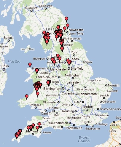
I’ve made this map of the 148 sites in the inventory, based on data in a table in the report:
http://www.owenboswarva.com/mwd/
The inventory is a requirement under Article 20 of the European Commission Mining Waste Directive (MWD), which states that: “Member States shall ensure that an inventory of closed waste facilities, including abandoned waste facilities, located on their territory which cause serious negative environmental impacts or have the potential of becoming in the medium or short term a serious threat to human health or the environment is drawn up and periodically updated.”
There are estimated to be nearly 100,000 closed or abandoned mines in England and Wales. This inventory highlights only those that present the most serious negative environmental impact based on the risk criteria applied by the Environment Agency. The EA report notes that existing data is incomplete and that “the inventory will be updated periodically and as new information is obtained”.
Almost all of the 148 sites are included in the inventory due to a potential for water pollution. However two (Spen Lane near Gateshead and Cortonwood Colliery near Rotherham) present a fire hazard, one (Ring Lows Quarry Tips north of Rochdale) presents an instability hazard, and one (Wheal Maid near Truro in Cornwall) presents a hazard to human health.